Overview
External Map Layers Setup allows administrators to import and display important map based data from external sources for displaying in v2Maps.
The feature currently Supports the following types: ArcGIS, GeoJSON, Insights Reports and ImageLayers.
Prerequisites
In order to use the map setup interface, you must:
- Have the " ExternalMapLayers" feature enabled within your Feature Setup.
- Have the "View and Edit External Map Layers" permission.
Installation
Map Setup is available within the core product from version 1.3+.
Accessing External Map Layers Setup
To access External Map Layer Setup you need the feature External Map Layers enabled within your features list. This will add the required menu option.

External Map Layers Setup

The External map layer setup page is broken up into 2 components. The External Map Layer Setup table and the Map Preview panel.
- The Layer Setup table is where the external map layer details can be viewed and edited.
- The Map Preview allows the user to Preview how the External Map Layer will look and behave on the map.
Setup Table

The Setup table displays all existing External Map Layer in the system. Each entry shows the layers Title, source data URL, whether the layer is currently being displayed in the Map preview panel and any actions that can be performed on a layer such as deleting or editing the layer.
The table can be filtered using the search bar above the table and clicking on table headings will sort the selected column.
To Toggle displaying the layer in the map preview click the eye icon in the displaying column.

To Edit or view an existing external map layers details click the Edit/View icon in the Actions column. This will display the External map layers details modal.
Note: You require the canEditExternalMapLayer permission to have the edit option available


To Delete an existing external map layer click the delete icon (This will open up a confirmation dialog).


Adding a new External Map Layer
To add a new External map layer. Click the Add External Map Layer above the setup table.
Note: You require the canEditExternalMapLayer permission to have the Add External Map Layer button available

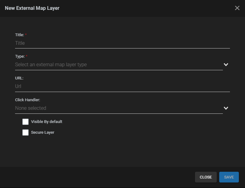
Clicking the Add External Map Layers button will display the External Map Layer details modal.

Depending on the source data the fields required to successfully add an external map layer will differ. Different fields will become available depending on the users selection. At the very minimum an External Map Layer requires a Title, Type and Url. Once the required information for the external map layer has been entered click save.
Below is a listing of all the fields and a brief description.
Title*: A descriptive name for the External Map Layer.
Type*: A dropdown of data types. This is the data type of your source data.

URL*: The URL of your source data.
Click Handler: A Dropdown of click handlers. Used to set custom behaviour when a marker on this layer is clicked ( see below). An additional click handler plugin may need to be installed so use this functionality.
Click Handler Attribute: Only shows when a click handler is selected. The name of the attribute to be passed into the selected click handler.

Visible by default: Show this layer by default? Checking this will show the External layer on the map automatically without needing to turn it on.
Secure Layer: Does this layer Require any authentication?
Currently only supported by ArcGIS layer type (see below)

Username: The username used to login to ArcGIS.
Password: The password used to login to ArcGIS.
Token Service URL: The url of the ArcGIS token service
Previewing External Map Layer
Once a layer has been successfully added click on the display icon in the setup table to view it in the map preview. This example is an ArcGIS layer displaying Police Stations in Miami-Dade county.

For certain map types the user may click on individual map markers to view their details. The information and how it is displayed depends both the external map layer type and the source data itself.

AutoSyncAttributes
The auto sync attribute feature gives the ability to tailor what information from the ArcGIS source is displayed. With this feature enabled ExternalMapLayers will automatically extract the Attribute fields from an ArcGIS source and allow the user to filter the displayed data using these fields.
To use this feature, you must:
- Have the AutoSyncAttributes feature enabled
- Have an ArcGIS data source
The Title is the name of the Property as given by the ArcGIS source.
The Type is the properties type as designated by the ArcGIS source. It can be used to inform you the format to be used for filtering.
The isVisible column allow administrators to decide which fields should be visible to users when viewing or editing the layer on v2maps elsewhere in the system such as site monitor or the views maps plugin. Below is an example of of An ArcGIS layer with only the name and address fields visible.

The Default Value fields sets the default the property will have when this layer loads. With the fields left blank there will be no filter applied. When a value is set only result matching the set value will be displayed on the map.
Viewing Insights Reports
To see more information on how to use insight reports and maps click here

Comments
0 comments
Please sign in to leave a comment.